and the British Museum
The Manuscript
The Map
The Man
The Manuscript
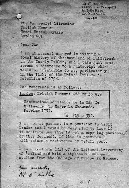
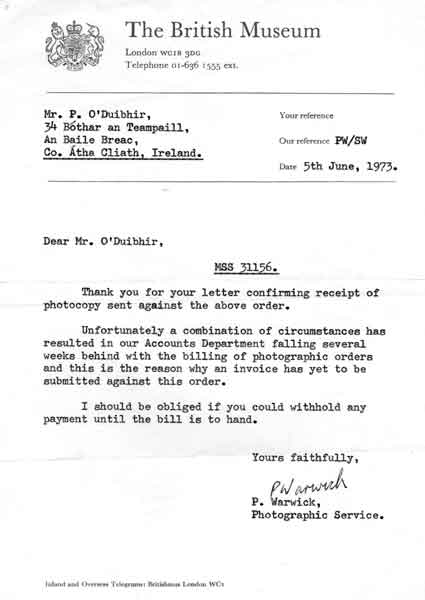
This whole thing started when I came across a reference in the Hayes Catalogue in the National Library of Ireland. I had been checking out the catalogue for every entry that might have any relation to the Killiney Bay area. This entry listed Reconnoisse militaire de la Baye de Killeeny (Killiney, Co. Dublin). By Major La Chaussée, Février, 1797. and said it was in the British Museum. So I wrote to the Museum (below) asking if I could get a copy and undertaking to pay for it.
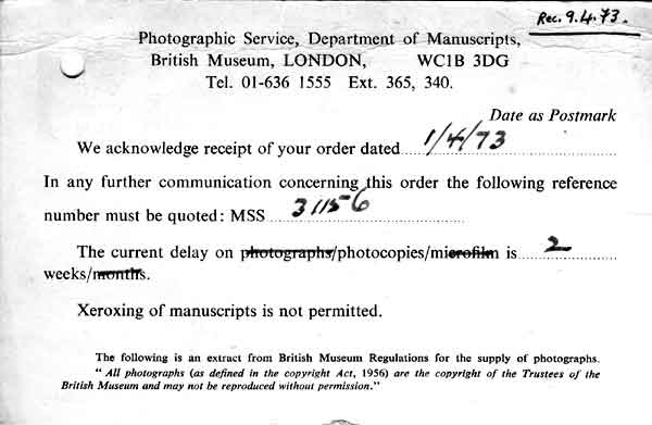
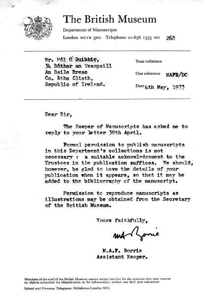
The Museum duly acknowledged my letter (below), told me that there was a two week delay in dealing with correspondence, and, ominously, added that manuscripts could not be Xeroxed (photocopied).
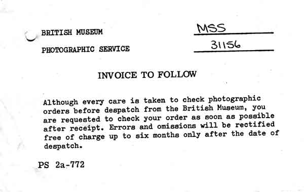
The copy finally arrived in the post and I was put on standby for the bill. (below)
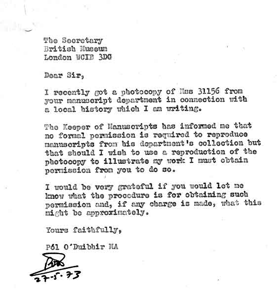
When I read the manuscript I realised what a fantastic discovery it was. It was a beautiful piece of work and set the bay in a military context from which your imagination would never again escape. So I set about asking the Museum what I would need to do if I wanted to publish it (below)
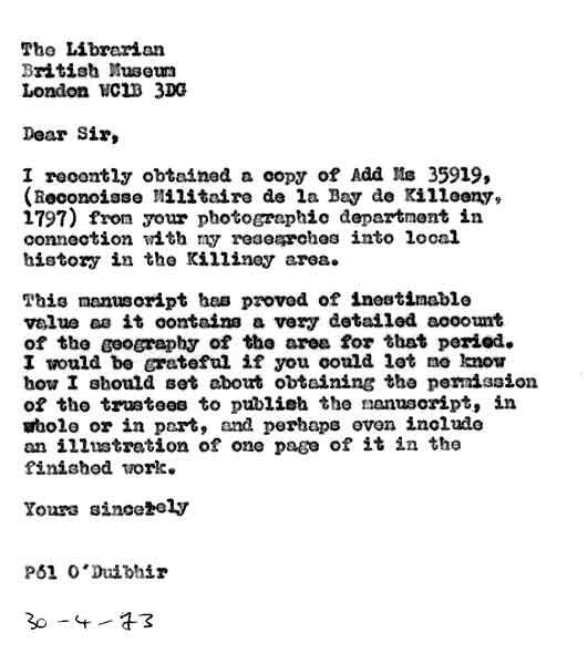
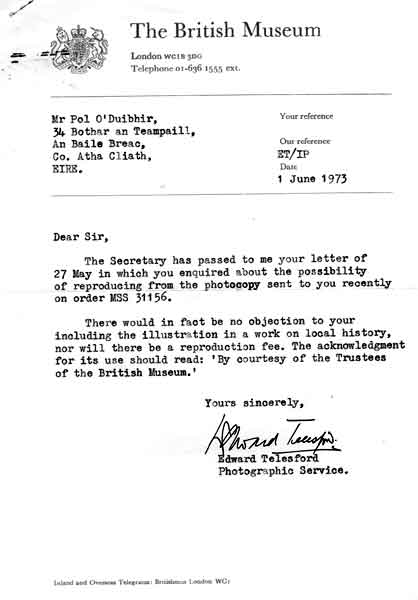
Much to my surprise there didn't seem to be any problem with publishing it and they would like details of where and when after the event so that they could immortalise me in the manuscript's bibliography. Fantastic. It also appeared that if I wanted to reproduce the manuscript, as distinct from pubishing its contents, I just had to ask the Museum secretary.
So I asked the Museum secretary.
And he didn't have a problem as long as I acknowledged the permission. And there was no fee.
Meanwhile the bill had not arrived and I was getting a bit nervous, so I wrote to find out what was going on.
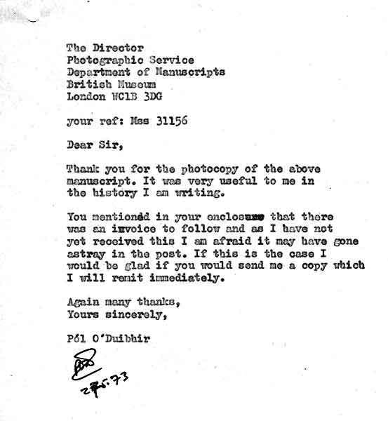
It appeared that their billing department was a bit behind and I was told to wait for the bill. My recollection is that when it came it was for 2/6d, bloody great value.
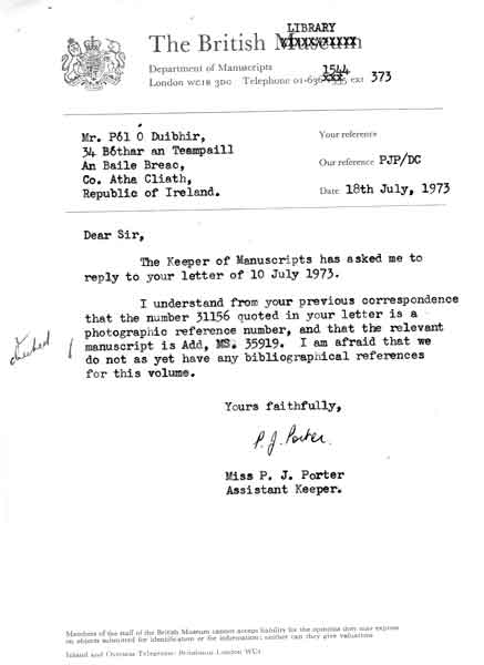
Meanwhile I had asked what the current bibliograpy of the manuscript was, as it had occurred to me that it might already have been published. This was one occasion when a NO answer was the right one. It had not yet been published. I was in with a first.
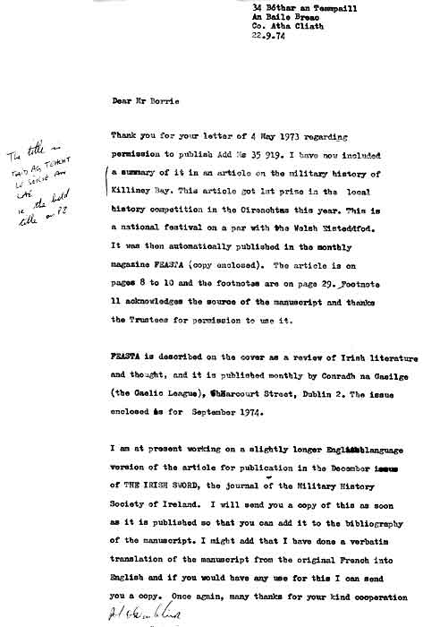
So as soon as it was published, the following year, I banged off a letter with details for the manuscript's bibliography.
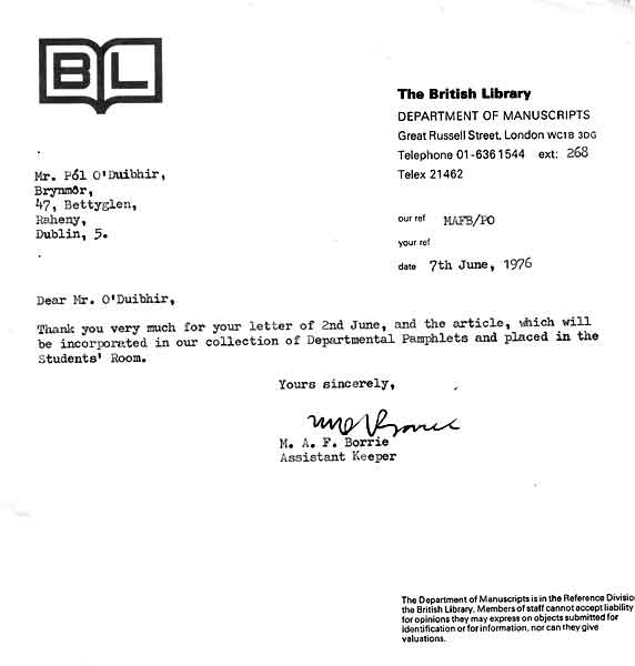
And it then appeared that I could also be read in the British Library.
So, for good measure, I also sent copies to the State Paper Office in Dublin Castle. (The Caitríona here is Caitríona Crowe. To this day she is playing a blinder on the Irish archival scene.)

Back to top
The Map
Now this is a whole other story altogether.
It was quite clear from the manuscript that it had originally been accompanied by a map. But there was no trace of any map with the copy in the British Museum/Library.
So I wrote to every conceivable institution looking for it. That is, all the institutions that I, as a complete amateur at this game, could conceive of as being relevant. I drew a blank at every turn. It was very frustrating. Along the way I had seen a map La Chaussée had done in the south of Ireland and it was fabulous.
So, for about thirty years, no sign of the map.
Then Niall O'Donoghue waded into his researches on the background to No.7 Martello Tower. His sister, Sylvia, and her husband, Doug, both retired and living in London, haunted the Public Records Office in Kew, combed it with a fine-tooth comb, chewed the records, digested them and then spat them out and chewed them again. A tour de force. And, they finally came up not with one map but with two.
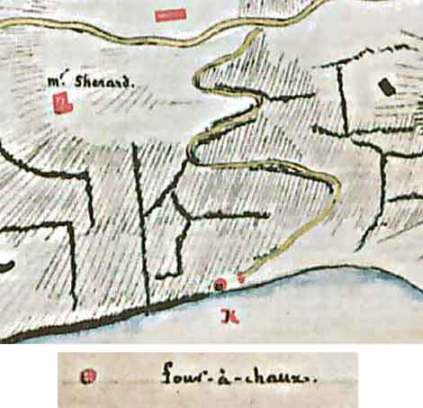
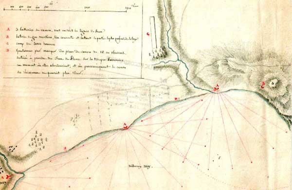
The first map not only illustrated the points in La Chaussée's report, but the mystery of the location of the limekiln which gave its name to No.8 Battery was also solved.
La Chaussée had it (four-à-chaux) marked on his map of 1797 (below).
It was quite clear from the manuscript that it had originally been accompanied by a map. But there was no trace of any map with the copy in the British Museum/Library.
So I wrote to every conceivable institution looking for it. That is, all the institutions that I, as a complete amateur at this game, could conceive of as being relevant. I drew a blank at every turn. It was very frustrating. Along the way I had seen a map La Chaussée had done in the south of Ireland and it was fabulous.
So, for about thirty years, no sign of the map.
Then Niall O'Donoghue waded into his researches on the background to No.7 Martello Tower. His sister, Sylvia, and her husband, Doug, both retired and living in London, haunted the Public Records Office in Kew, combed it with a fine-tooth comb, chewed the records, digested them and then spat them out and chewed them again. A tour de force. And, they finally came up not with one map but with two.
The first map not only illustrated the points in La Chaussée's report, but the mystery of the location of the limekiln which gave its name to No.8 Battery was also solved.
La Chaussée had it (four-à-chaux) marked on his map of 1797 (below).
and Niall had it from military papers relating to 1845 when the army was selling land adjacent to the kiln to the railway company (below). The dotted vertical area at the left is the proposed line of the railway. The horizontal road is the Military Road, and the red building is the limekiln. The vertical blue line on the right is the coastline.
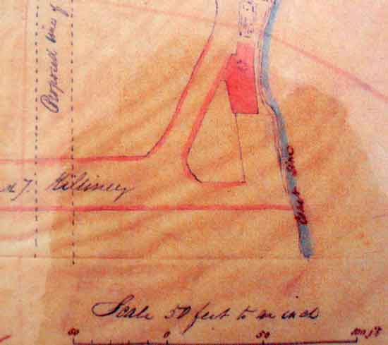
The location is at what is now the path down to the beach at the northern end of the Strand Road/Holy Child Convent bridge over the railway line.
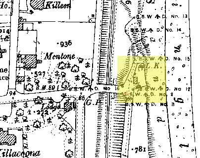
And, once we knew where it had been, it turns out to have been shown on the OS maps all along.
In the case of the 1900 25" map it is actually marked as L.K. (below)
And, once we knew where it had been, it turns out to have been shown on the OS maps all along.
In the case of the 1900 25" map it is actually marked as L.K. (below)
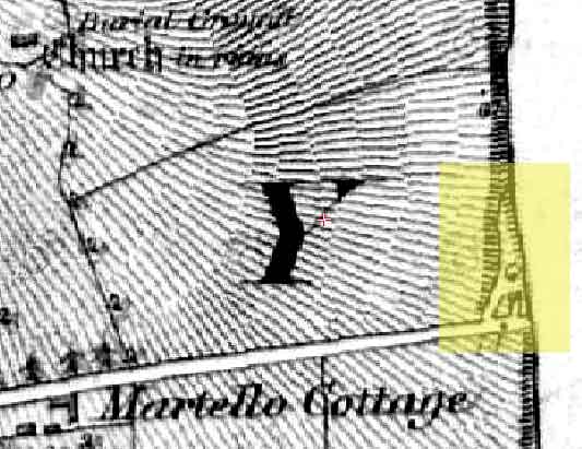
And on the 1837 6" it is shown but not marked (below).
So a lot of things "fell" into place. Well that's not fair. They were hacked, moulded and sculpted into place through the sterling efforts of Doug and Sylvia. To whom eternal thanks.
.
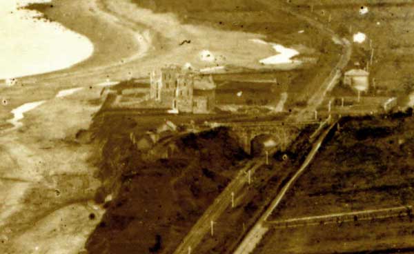
Incidentally you can also see the old Ballybrack railway station, the two-storey house on the right, which was still operating as a station when this photo was taken. You cannot see Martello Tower No.6 which is directly behind the castellated houses.
Once you become sensitised to something it's amazing what you notice. I was recently checking out an old pre-1882 Lawrence print in relation to something else when what did I see but the Limekiln itself. Hover the cursor over the image above to highlight it.
Update (April 2013): The above limekiln was certainly in the position shown in c.1850. However, following a talk by Rob Goodbody on the local road system over the years, I am now wondering if the location shown on La Chaussée's map (1797) might refer to an earlier kiln at the bottom of the Kilmore/Saintbury Avenue, which served as the principal road to the coast before the construction of the permanent military emplacements in 1804.
The second map was even more interesting. It detailed the precise locations where it was recommended to set up Batteries to keep the ships at bay and Epaulements to rake the beaches with anti-personnel fire should enemy troops succeed in landing. Six positions in all were specified and these corresponded almost exactly with those where six of the subsequent nine Martello emplacements were located.
The Man
I was very curious about who this Major La Chaussée might be. I came to the conclusion that he had been a major in the French army, had fled France after the Revolution and was now working for the British. I was told that this would not be out of kilter with the times as there was as much, if not more, solidarity across the officer class in the various national armies as there was loyalty to their respective nations.
But when I first came across the title of the manuscript I didn't know what to expect. I assumed it was a survey done on behalf of the French military in advance of a seaborne attack. When I got the manuscript and started reading it, my excitement mounted. This appeared to be a Frenchman who was spying out the land in such detail as would blow your mind. He even knew who was living in each of the big houses. On that basis, it was an astounding document. I might even become famous myself.
However, my baloon was abruptly burst when I came to the end of the document and discovered Lord Carhampton's orders. The Major had actually been working for the British, surveying the Bay to determine how best to defend it against the French. Still, it was a find of sorts.
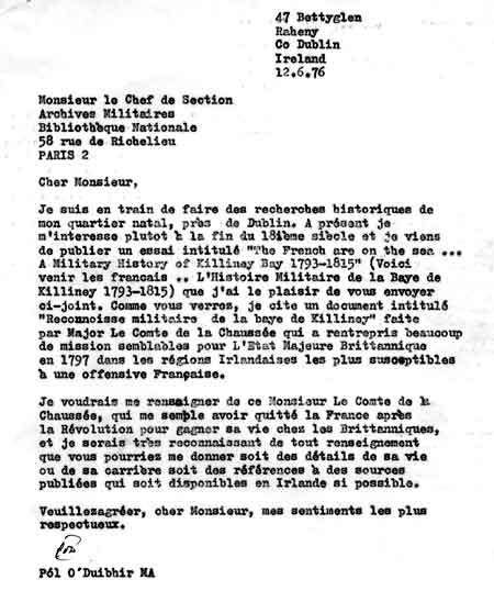
Anyway, I wrote to the Military Archive in the French National Library (La Bibliotheque Nationale), enclosing a copy of my article and asking for anything they might have on the Major. [Please ignore the grammar mistakes, I might even have corrected one or two in the top copy at the time. They are certainly glaringly obvious to me at this stage.]
But when I first came across the title of the manuscript I didn't know what to expect. I assumed it was a survey done on behalf of the French military in advance of a seaborne attack. When I got the manuscript and started reading it, my excitement mounted. This appeared to be a Frenchman who was spying out the land in such detail as would blow your mind. He even knew who was living in each of the big houses. On that basis, it was an astounding document. I might even become famous myself.
However, my baloon was abruptly burst when I came to the end of the document and discovered Lord Carhampton's orders. The Major had actually been working for the British, surveying the Bay to determine how best to defend it against the French. Still, it was a find of sorts.
Anyway, I wrote to the Military Archive in the French National Library (La Bibliotheque Nationale), enclosing a copy of my article and asking for anything they might have on the Major. [Please ignore the grammar mistakes, I might even have corrected one or two in the top copy at the time. They are certainly glaringly obvious to me at this stage.]
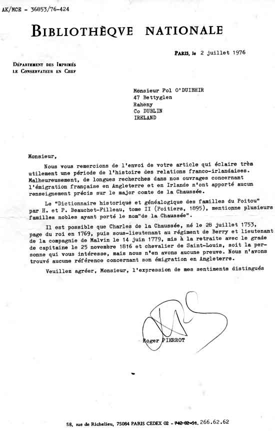
I got a typically florid reply from the French. I was chuffed that they thanked me for my article which they said "usefully illuminated a period of Franco-Irish relations". Unfortunately, they said extensive research into their resources concerning French emigration to England and Ireland had thrown up nothing on La Chaussée.
It turned out that there were many families among the nobility with the name La Chaussée. They tentatively suggested that a particular guy called Charles, who had a distinguished military record, might be the one I was looking for, but there was, of course, no proof.
The only problem was that he retired in 1816 with the rank of captain and the title of chevalier de Saint-Louis, and there was no record of him emigrating to England.
I had thought that if he was still working for the French in 1816 he was hardly my guy. But I now realise there was a Restoration in 1815 and our La Chaussée could have returned to France and subsequently retired from the Royalist army. The discrepancy in rank, a major in UK and a captain in France, might be explained by the major being a British rank and his reverting to a captain on his return to France.
So it's still all to play for, and I'm still waiting on my Légion d'Honneur.
Some breaking news.
In 1792, he seems to have been involved with the viscomte de Calonne, who was in exile in Germany and was attempting to overthrow the revolutionary government.
In 1796/7 he was certainly in Ireland, advising on defensive measures against a possible French invasion (eg Killiney & Bantry).
In 1799-1800, he seems to have been in London and in close contact with Philippe d'Auvergne (Duc de Bouillon) who was in charge of British assistance to, and liaison with, Royalist émigrés. D'Auvergne was from, and was based in, Jersey (CI) and had a particular responsibility for intelligence gathering for the British.
There is a tantalising reference to Le comte de la Chaussée in a book on the “Despard Conspiracy”. Colonel Despard was an Anglo-Irish rebel who attempted to stage his own version of the French Revolution in London in 1801. He and 6 of his co-conspirators were executed in 1803.
Meanwhile, it is established that La Chaussée passed on money, on behalf of the British government, to finance the failed plan by Picot and Lebourgeois to assassinate Napoleon. Both these gentlemen were captured and executed.
There is also correspondence from Georges Cadoudal, leader of the Chouans, to both La Chaussée and Philippe d'Auvergne.
This is potentially exciting stuff and I'll report back here as soon as anything more concrete emerges.
You can check out the following versions of the Reconnoisse
(PDFs): Ms from the BM Typescript of Ms Translation of Ms
(jpeg): Map1 Map2
I would like to thank the British Museum/Library for permission to reproduce the manuscript and the UK National Archives for permission to reproduce the maps.
(PDFs): Ms from the BM Typescript of Ms Translation of Ms
(jpeg): Map1 Map2
I would like to thank the British Museum/Library for permission to reproduce the manuscript and the UK National Archives for permission to reproduce the maps.
Back to top